Located just west of Chicago’s downtown “Loop”, the West Loop is a vibrant and rapidly growing urban neighborhood in the heart of the city. The area has undergone several transformations over the years since settlers first arrived in the area in the early 1800s.
Neighborhood Composition
The boundaries of the West Loop are generally considered to run from Grand Avenue on the north to I-290 on the south and from Ashland on the west to the Chicago River on the east. There are many distinct neighborhoods that exist within these boundaries, including, but not limited to:
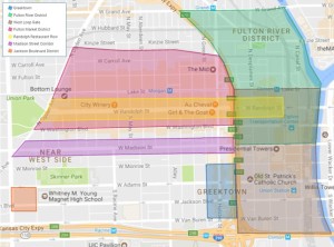
Existing West Loop Neighborhoods and Historic Districts
- Greektown – Centered on Halsted Street from Van Buren to Monroe, Greektown (formerly known as “the Delta”, is home to many traditional Greek restaurants, the National Hellenic Museum, and the annual Greek Independence Day Parade.
- Fulton River District – This district covers the northeast corner of the West Loop, from the Chicago River on the east to the Kennedy Expressway and from Madison Street to Ohio Street on the north.
- West Loop Gate – As the western gateway to the downtown, the West Loop Gate overlaps the Fulton River District, running from I-290 to Lake Street between the Kennedy Expressway and the river. It includes the historic Old St. Pat’s Church, Union and Ogilvie train stations, and the Haymarket Memorial.
- Fulton Market District – The Fulton Market District (Washington to the rail tracks north of Carroll Avenue, Halsted to Ogden) is a landmarked district with a dynamic mix of meatpacking companies, world-class restaurants, and manufacturing businesses.
- Randolph Restaurant Row – Internationally known, the stretch of Randolph from Clinton all the way to Ogden is home to arguably the most popular lineup of restaurants in the Midwest.
- Madison Corridor – Known as the “Main Street of the West Loop”, Madison Street from Halsted to Ogden contains a mix of bars, restaurants, local shops, and other businesses that cater to neighborhood residents and visitors alike.
- Jackson Boulevard Historic District – A preserved section of homes dating from the 1880s and 1890s in the area bounded by Ashland, Laflin, Adams, and one half block south of Jackson.
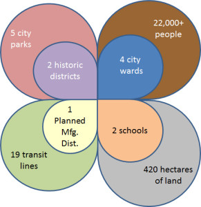
The neighborhood includes nineteen CTA transit lines (Blue, Green, and Pink, L lines and the #1, 7, 8, J14, 19, 20, 37, 28, 56, 60, 124, 125, 126, 151, 156, and 157 bus routes), five parks (Bartelme, Fulton River, Heritage, Skinner, and Union), four City wards (25th, 27th, 28th, and 42nd), two public schools (Mark T. Skinner Elementary, Whitney Young High School) with numerous private schools, two historic districts (Fulton Market and Jackson Boulevard), and one Planned Manufacturing District (PMD) (Kinzie Corridor).
Demographics
In the 1960s and 1970s, it was estimated that approximately 10,000 – 15,000 men lived along a section of Madison Street nicknamed “Skid Row” in flop houses and on street curbs. Today, that street looks very different for the nearly 33,000 West Loop residents.[1]
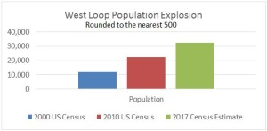
West Loop Population Growth, 2000-2017
The changes to the West Loop of late are not only dramatic, but equally impressive in how quickly these changes have occurred.
The composition of the West Loop resident group has also changed with many Millennials choosing to remain in the city and raise their children in the family-friendly West Loop. Yet, while the number of households with children has increased significantly, the West Loop remains a diverse generational neighborhood with adult households ranging from young Millennials to empty-nest Baby Boomers.
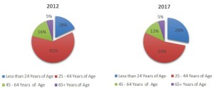
Age Distribution of West Loop Residents, 2012 & 2017
From warehouses and the downtrodden to artists and entrepreneurs – it’s interesting to speculate whether or not the meat packers of the 1800s, or even the developers of the 1980s, could have imagined all the ways that the West Loop has transformed.
Commercial development has also been unprecedented with a significant amount of office and retail space being built. Formerly home to National Biscuit Company (Nabisco) and Armour Meatpacking, the West Loop is now called home by Boeing, Google, and (soon) McDonald’s Corporation. Since 2010, a total of 42 companies (each requiring 10,000+ square feet of office space) have moved to the West Loop – nineteen such companies in just the last five years.
For example, at 535,000 sq ft, the new 1K Fulton building is home to Google’s Chicago office. The site of the former Harpo Studios is currently being redeveloped into a 600,000 sq ft retail and office building which will be home to McDonald’s new global headquarters, which will occupy 485,000 sq ft and serve 2,000 employees.[2]
The influx of so many companies and employers has significantly impacted median household incomes for the area. As shown in Figure 4, salaries for West Loop residents have nearly doubled between 2000 and 2017.[3]
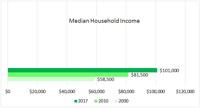
West Loop Household Income
Posted: February, 2018
[1] 1990-2010 Census, 2012 Estimates with 2017 Projections; Gallun, Alby. Apartment Market Starts to Tilt in Tenants’ Favor, Crains, February 14, 2017; McKuen, Pamela Dittmer. Since Great Recession, West Loop has been one of the City’s Hottest Housing Markets, Chicago Tribune, September 07, 2016
[2] Bentle, Kyle. Data: Which Companies are Moving Downtown, Chicago Tribune, June 15, 2016; Collier’s International. Research & Forecast Report, Fourth Quarter 2016 & First Quarter 2017, Downtown Chicago/office
[3] Niche.com West Loop Residents Demographics, Niche.com, June 2017